

Caption: 24 hour quantitative precipitation estimates from radar across Scotland for Storm Frank (29th – 30th December 2015). Typical catchment average rainfall exceeded 80 mm in 24 hours for the Upper Dee, with some point estimates of 150 mm. All background radar data © Met Office.
The past two months have brought significant rainfall across much of Scotland resulting in some severe disruption due to the impacts of flooding. Impacts have been seen in early December with Storm Desmond, through to Storm Frank which brought major flooding along the Dee Valley in Northern Scotland.
The use of radar is essential to increase our understanding of the spatial representation and real time estimation of rainfall for flood forecasting across Scotland. However, whilst this is a vital tool there are some unique challenges with doing so in Scotland not least the effects of the upland environment and distance from the radar. To this end the flood forecasting service are working with the National Centre for Atmospheric Science (NCAS) and the University of Leeds to deploy a mobile X-band radar to research the use of high resolution radar measurements for improved flood forecasting.
The RAINS project (Radar Applications In Northern Scotland) will run from January to July 2016 and will be making detailed measurements of the atmosphere from a radar based in Kinloss, Morayshire, specifically looking to measure clouds and rainfall as they form across Northern Scotland. The NCAS radar is capable of measuring clouds and precipitation in high detail and is the only one of its type in the United Kingdom.
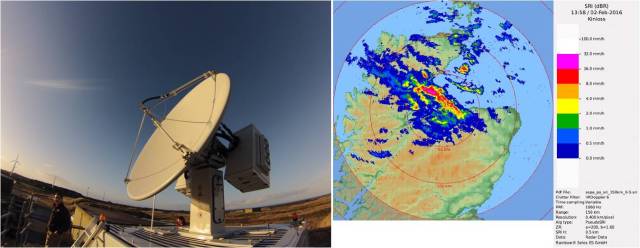
The mobile X Band radar deployed at Kinloss Barracks in Moray (left) and initial quantitative precipitation estimates on the 2nd February (right) when flooding occurred across Ross-shire.
The collaborative project involving the Met Office and Scottish Water will specifically look to improve the understanding of rainfall and the prediction of floods through comparative hydrometeorological modelling using the quantitative precipitation estimates of rainfall generated by the Kinloss radar.
