

In August this year, SEPA published its new Flood Warning Development Framework. The framework defines the direction of travel for flood forecasting and warning services in Scotland with the aims to maintain and improve existing, and deliver new, operational flood warning services; upgrade capabilities through development and innovation; and deliver enhanced digital communications and an engaged and customer focused service. So what does this Framework mean for surface water flood forecasting capabilities?
In previous articles (Quick as a Flash Part 1 and Part 2) we’ve commented on how science developments have supported new first guess forecasting tools to handle the uncertainty in predictions. Although, the development of such tools was only seen as the first step, at the time we said “if we are to truly get to grips with surface flooding, we are likely to need much better weather prediction models and many more alternative forecast scenarios to properly quantify the uncertainties. This will require substantially more super-computing capacity in the years ahead.”
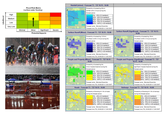
Later developments have included the implementation of the UK’s first operational surface water flood forecasting system operating at a 24-hour lead time. The approach combined advances in the science of forecasting convective rainfall events in the Met Office with a new blended ensemble (MOGREPS-UK) and nowcast ensemble combined with the use of SEPA’s pluvial flood risk maps and made operational through the Grid-to-grid model within the FEWS platform.
As described, following the trial of this system “The lesson we learnt during the (Glasgow) Games is that the staffing requirements to operate such a service are high due to the need to continually monitor the forecast, given the variability between model runs, and the briefing requirements to help end users understand the uncertainty.”

As set out in the Framework, SEPA as part of our work with the Scottish Flood Forecasting Service, intend to develop new capabilities for surface water flood flooding for the public and infrastructure sectors such as transport. As referenced in the Framework, a recent Discovery report has set out a future road map for developing our approach to this challenge.
The Discovery report puts forward five recommendations. The first to ensure we have competent staff to enable confident decision making in uncertainty. Further recommendations propose coupled meteorological and hydrological approaches to forecasting, building on recent research towards improved surface water flood forecasts for Scotland. The report concludes that we should explore how we work in partnership with other agencies in supporting a climate resilient infrastructure and explores the topic of warning for surface water events. As suggested following the London floods of 2021, there could be justification for having stand-alone warning systems for pluvial flooding.
Following the Pitt review into the 2007 floods, the UK witnessed a step-change in hydrometeorological capabilities with significant advances in river and coastal forecasting. It’s not impossible to imagine that we now need a similar step-change in capabilities to ensure we are prepared for the future impacts of surface water flooding due to climate change.

Pingback: New surface water flood forecasting tool for Scotland now operational. | Scottish Flood Forecasting Service