
In this article, we take a retrospective view on a decade of challenges and achievements for the flood forecasting service with some of the many people who have made it a success. A period when Bertha, Ciara, Desmond, Dennis and Frank all became popular household names in the forecasting community, what a ten years it has been…

Following major flooding in 2007, the Pitt Review made recommendations for hydrological and meteorological forecasting services to come together to provide technical capabilities of forecasting, modelling and warning against all sources of flooding and increasing the preparation lead times for emergency responders. Whilst the Flood Forecasting Centre for England and Wales was established in 2009, other European Centres such as the national forecasting centre in France (SCHAPI) was held up as a good example to follow having developed a programme of forecasting service improvements such as the Vigicrues service – aimed at improving vigilance to flood risk.
Alan Motion (Former Head of Strategic Relationships for Devolved Administrations at the Met Office) explains the strategic drivers behind the service back in 2010: “To achieve an operational flood forecasting service in Scotland the first vital step was to bring key stakeholders on-board, especially within the prospective delivery partners and the relevant areas of Scottish Government. Gaining an understanding of the practicalities and politics involved was identified as a key factor even before we got to the drawing board. Reaching out to both national and international colleagues was vital to the success of that quest. The challenge then was in assessing the knowledge gained against the resources we felt may be available to us to support delivery of a science-led, largely user-defined, service for Scotland.”
As Alan says, establishing the service was at the time, “…full of challenges and the usual ups and downs such projects experience but very fulfilling.”
The virtual centre of expertise, building on existing operational teams at SEPA and the Met Office in Perth and Aberdeen, went live on the 9th March 2011. However, this was not without various challenges as Richard Maxey (SFFS Co-ordinator at SEPA) explains: “When I joined SEPA at the end of August 2010, apart from the concept and the agreement to resource and launch the service, there was very little actually in place. With the launch a mere six months away, we had to develop a Flood Guidance Statement, and work out how we would deliver it operationally …nothing will match the frenzy of activity that led to the initial launch of the service but by February 2011 we had a product and a process.”

Collaboration has remained key to the success of the forecasting service. As Pete Buchanan (Former SFFS Co-ordinator at the Met Office) explains: “Working with multidisciplinary colleagues in the respective Met Office and SEPA organisations demonstrated how much could be achieved in a relatively short timescale. The commissioning and early consolidation of the SFFS provided an effective, efficient and often innovative approach to flood forecasting in Scotland.”
Underpinning the service with a science-led approach to forecasting across Scotland has been crucial, especially in the early stages when systems were limited. New coastal forecasting systems have been implemented and a Heavy Rainfall Alerting system to support surface water flooding introduced. One of the most significant achievements and game-changer for forecasting capabilities for the whole of Scotland was the introduction of the five-day countrywide river forecast. The approach was to couple high-resolution numerical weather prediction models with a 1km gridded hydrological model, to forecast the potential for flooding for the whole of Scotland. Richard explains: “These early days were accompanied by a rapid uptake of forecasting products, such as the Grid-to-Grid model and a rejigged daily weather forecast from the Met Office more suited to the new ways of working.”

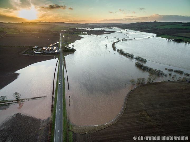
Along with the science and system challenges, there were some very early operational challenges. The Dumfriesshire Floods of December 2013 was one of the first significant events, which resulted in an Amber Flood Guidance Statement. This was followed in 2014 by the remnants of ex-tropical storm Bertha that caused significant flooding across Morayshire. In both cases, the use of the hydro-meteorological modelling in G2G proved important in the early identification of the specific flood risks. The then Environment Minister, Paul Wheelhouse, commented following the Dumfriesshire flooding “I was extremely impressed by how well prepared all the authorities were – aided by the timely and accurate flood forecasts from the Scottish Flood Forecasting Service”.
Focusing on the impacts of flooding has increasingly been the focus of the daily decision making process, with the meteorologists and hydrologists always asking the question, how bad is it likely to be and where are the impacts. As a meteorologist for the service and former BBC weather reporter Peter Sloss explained in an article in 2014 … “(we have seen) a huge improvement with few surprises during the evolution of a weather event. Always fine-tuning the details of the weather forecast up to and during the event and communicating this message to all concerned. Also… the meteorologist is much more focussed on the impacts of the rainfall rather than just the amount of rain expected.”
During the ten years, there has been no greater flooding impact than during the winter of 2015 and 2016 with a succession of storms including Desmond and Frank. Storm Frank alone was severe with 101 Flood Warnings issued across Scotland, two Severe Flood Warnings and over 1,000 properties flooded. Karen MacDonald was a flood forecaster during this spell of flooding and recalls her experience: “Storm Frank was one of the first flood events that I was primary forecaster for. I had only been on the (forecasting) rota for 6 months so I was keen to get some weather to test my new skills but I remember seeing the forecast coming in and knew that this was an exceptionally big one! Across the country, most of Scotland’s major rivers were flooding so it was challenging to keep monitoring them all simultaneously.“

That winter of 2015/16 witnessed the issuing of the first Red Flood Guidance Statements and really tested the capabilities of the service. As Karen says: “Although this was an incredibly demanding flood event to deal with, I am glad that I was able to contribute to the response and am exceptionally proud of what we managed to achieve. Despite the widespread significant flood impacts, our Flood Guidance Statement and messages were able to provide the information to the responders on the ground that needed it to assist the public. That is why we do the work that we do, to help others and to make a difference. So as a new forecaster I was able to see first hand of the benefits that our service provides and appreciate the value of my new skill.”
As Karen says, improving the vigilance and preparedness to flood events has always been a primary aim of the service. Following Storm Frank, Mark Thomson, Principal Resilience Adviser at Dumfries and Galloway Council said, “It’s not just about the Forecasts/Alerts, it’s about the added value that the experts can offer when you want more detail regarding potentially vulnerable areas. It is fair to say that the SFFS outputs are the most important forecasts we receive on a daily basis, given the vulnerabilities we have! The key piece of information was … predicting record breaking levels on the Whitesands, that could exceed those experienced in 2009, 2013 and potentially as far back as 1982.”
As for forecasting science challenges, there is none greater than surface water and the ability to predict the timing, location and impacts of convective events. In the build up to the 2014 Commonwealth Games and understanding of the potential for disruption due to surface water flooding as seen in 2002, research was commissioned into how to develop a city-wide forecasting system. As Linda Speight (former SFFS Senior Hydrometeorologist) explains: “Developing the surface water flood forecasts for the Glasgow Commonwealth Games was an exciting opportunity to see what was possible with the emerging scientific capabilities for forecasting intense rainfall.”
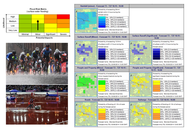
“The conversations between decision makers, meteorologists, hydrologists and model developers gave us a unique perspective on balancing end user needs with science and practical limitations. It truly was a co-designed product. Involving everyone early on meant there was a shared understanding of the uncertainties in forecasting the timing and location of surface water flooding and hence realistic expectations of the output. Although there were still some interesting communication challenges for the SFFS during the Games!”

The system successfully operated during the 2014 Games and in 2019 was awarded the Innovation Prize by the Royal Meteorological Society. Now a research scientist at Reading University, Linda says: The resulting innovative approach continues to be a leading example of operational surface water forecasting capability and 6 years on I am still regularly asked about this work.”
The global pandemic has provided challenges for many operational services. The forecasting service has had to adapt and work in different ways whilst still maintaining the critical role of providing the early forecasts and guidance to responders. As Jess Pryer (SFFS Co-ordinator at the Met Office) says: “The last twelve months have been a testing period for the Scottish Flood Forecasting Service, however despite this, neither organisation has stood still and we have embraced the challenges of COVID restrictions, exploiting technology and adapting our working practices a lot more quickly than we may have done.”
Cordelia Menmuir (SEPA’s Flood Forecasting and Warning Manager) recognises the significant importance of the forecasting staff that drive the service: “At SEPA we have always maintained that it is our knowledgeable staff, their experience and commitment to do the best they can to protect the people of Scotland that underpins the Flood Forecasting Service. Never has this been more apparent than over the last 12 months. I am immensely proud of what has been achieved. If we are to be ready to face the next challenge that gets thrown in our direction it is essential that we learn from our experiences and continue to build back better and stronger than before.”

Breach of the Union Canal resulting in water from the canal to spread across neighbouring fields causing flooding of the Edinburgh to Glasgow rail line following extreme rainfall in August 2020. Source: Scottish Canals
Likewise, Jess reflects on what we have experienced: “I want to learn and build on these changes going forward to help the partnership evolve, collaborating more effectively in the future using each organisations expertise to develop and improve flood forecasting for Scotland.”
So what may the next decade bring? One of the main science priorities remains addressing the ‘Grand Challenges‘ of surface water flood forecasting with work progressing to develop this capability further. We witnessed some extreme rainfall in August 2020 that acts as a stark reminder of the potentially devastating impacts of these types of events under a changing climate. We are also expanding the reach of the forecasting service as a new 3-day flood forecast product is set to launch later in 2021 to the public, a big leap from the partner-only service currently provided.
Author acknowledgements – huge thanks to everyone that has contributed and supported the service over the past decade. A selection – of the many – words from a handful of people involved have been used in the article but appreciate there are so many others that have made the service a success- many thanks to you all!
