
After 18 months of hard work from ourselves, CEH Wallingford, Deltares, Met Office and the James Hutton Institute, our Glasgow surface water flood forecasting model is now operational (previous updates available here and here). We believe this is the UK’s first operational surface water flood risk forecast with a 24 hour lead time.
The model combines recent advances in the science of forecasting convective rainfall events in the Met Office blended ensemble and Nowcast ensemble with SEPA’s new pluvial flood risk maps. The Centre for Ecology and Hydrology Grid-to-Grid model (Moore et al., 2006, 2007; Bell et al., 2009) is used to convert the forecast rainfall from each ensemble member into surface runoff. This is used to link the rainfall event to SEPA’s existing library of impact assessments to give a fully risk based forecast. We have separated the impacts into two categories; people and property, and transport. Thresholds have been assigned to allow us to compare the forecast impacts directly with the existing flood risk matrix used by the flood forecasting service.

The surface water flood risk assessment methodology
The model will run eight times a day. The output will be used to produce surface water flood risk guidance during the Commonwealth Games which will be fed directly into the Multi Agency Control Centre through SEPA’s Resilience Officers. The guidance is also available to other category 1 and 2 responders in Glasgow and will enable proactive action to help minimise the impact of potential flooding, and reduce recovery time. After the Games the model will continue to run for the rest of the summer and will help inform our future development of surface water flood forecasting across Scotland.
The first heavy rainfall event that we have seen in the model showed some promising results. On 10th June there were heavy showers forecast across south west Scotland with a small probability of rainfall exceeding 20mm in 3 hours across Glasgow. This borderline type of event is what we are most likely to see during The Games. The model highlighted a low overall flood risk due to the potential for significant impacts, particularly for transport, although the probability of this occurring was very low. On the afternoon of 10th June some minor transport disruption was reported in Glasgow with flooding of roads in known vulnerable locations.
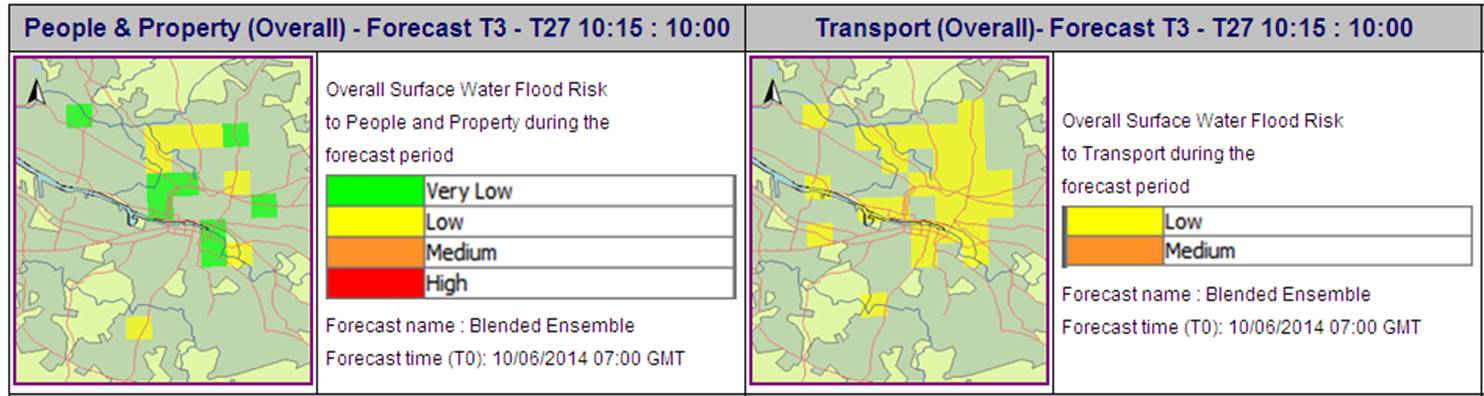
Model output showing the overall surface water flood risk to People & Property and Transport on 10th June
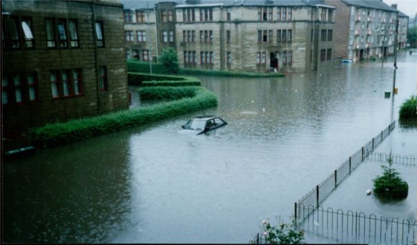
Glasgow in July 2002 (source Dennistoun online ). A sight that hopefully won’t be repeated 12 years on.
While we hope for a dry fortnight for The Games, the flood forecasting service is now well prepared to provide additional surface water guidance directly into the Commonwealth Games Multi Agency Control Room using cutting edge science. We hope that our experience of using the new surface water flood forecasting tool over this summer will help us to improve our surface water forecasting for other areas of Scotland in the future.

Pingback: BHS 2014 Challenging hydrological theory and practice and calling for better communicators | Scottish Flood Forecasting Service
Pingback: Surface water flood forecasting during the Commonwealth Games | Scottish Flood Forecasting Service
Pingback: Forecasting Flood Risk from Surface Water Flooding | enauk
Pingback: High Impact Weather and Climate Conference | Scottish Flood Forecasting Service
Pingback: Royal Meteorology Society Award for the Scottish Flood Forecasting Service | Scottish Flood Forecasting Service