
Peter Buchanan, the Met Office flood forecasting service coordinator, describes one of the key priority areas for forecasting science development.
“One of the greatest challenges facing the flood forecasting community for the foreseeable future is surface water or pluvial flooding such as the event seen in Edinburgh in 2011.
There have been steady and tangible improvements in the forecasting of broad scale river flooding events to the extent that these, in the main, are increasingly less likely to spring a nasty surprise on us. As well as improving the quality and reliability of fluvial flooding forecasts there have been complementary gains in forecast lead time and importantly the assessment of risk. The net result has been better, more timely advice and decision making for public and responders and by implication improved security and loss mitigation.
Nonetheless, considerable challenges remain in relation to the prediction of surface water flooding. Why is this? Surface water flooding is usually the outcome of high intensity, localised weather phenomena. By its very nature it tends to be less predictable. As such, it pushes our weather science to the limit. Putting this into perspective, the maximum lead time for a reliable forecast of a thunderstorm is three hours. The maximum lead time for a reliable forecast for a broader scale, rain bearing weather front is typically several days with the difference in scale between features being significant.
It is the small scale and relatively chaotic, nature of heavy rain that makes it very difficult to predict accurately. If we are to justify greater precision in our forecasts in terms of timing, location, intensity and duration we will need to demonstrate significant gains in their accuracy. Although important advances in forecast accuracy have and will continue to be made, the provision of reliable deterministic (yes or no) predictions of localised intense rainfall is likely to remain beyond our capabilities for some years to come.
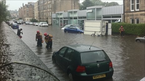
Flooding in Edinburgh. Source: BBC, 2011.
Does this mean we should give up for the time being? The answer is no because our weather prediction models are capable of representing intense rainfall (i.e. they can resolve individual thunderstorms), even if their forecast accuracy in terms of location and timing are uncertain. In other words, we can now be quite accurate in our predictions of the occurrence of intense rainfall even though we are uncertain about its precise location and timing. If we take a probabilistic approach to the prediction of such events, then we can still deliver a service which provides useful guidance and, critically, an objectively based risk assessment.
By applying our knowledge of the uncertainties in the timing, location, intensity and duration of heavy downpours, we can develop sophisticated tools to help us quantify the likelihood and impacts of surface water flooding.
To this end, the forecasting service introduced a Heavy Rainfall Alert (HRA) tool in the spring of 2013. Prior to the development of this tool we completed a study to derive a set of relationships between the intensity and duration of heavy rainfall and its associated impacts for a range of warning areas. A set of heavy rainfall thresholds have been incorporated into an automated tool designed to process numerical weather forecasts and provide those involved in operational hydrometeorology with probabilistic forecast guidance for such events”. Part 2 to follow…

Pingback: Recent flood impacts and forecasts: how well did we do? | Scottish Flood Forecasting Service
Pingback: Surface Water Flooding in Aberdeen | Scottish Flood Forecasting Service
Pingback: Surface water flood warnings in England: overview, assessment and recommendations | Flooding From Intense Rainfall
Pingback: Surface water flood forecasting: where next? | Scottish Flood Forecasting Service