
SFFS currently have the capability to forecast flows “everywhere” in Scotland, at a 1km grid scale up to five days ahead, using the Grid to Grid model. This includes calculation of snow fall and melt, and the production of probabilistic forecasts. Whilst it is possible to compare forecasts with theoretical indicators of high flows (such as predetermined return periods) and known flood warning thresholds at particular locations, there is currently no simple direct way to determine the actual flooding impact implied by a forecast flow at a point.
Over the past two years SEPA have been publishing outputs from the National Flood Risk Assessment study, including maps of flood risk and potential vulnerable areas. In 2013 we are publishing more detailed pluvial and fluvial maps of flood risk, showing the vulnerability of various receptors, such as human health, the economy and transport.
We now plan to take advantage of these developments and develop dynamic flood impact and hazard assessments, allowing key land areas that are vulnerable and imminently at risk to be readily identified. We will be linking rainfall forecasts and G2G model forecasts with flood impact datasets. The aim is to use the spatial data generated in G2G to facilitate dynamic mapping of a range of flood hazards. We have engaged the Centre of Ecology and Hydrology to carry out this work, which is complimentary to their input to the Hazard Impacts Model being delivered through the Natural Hazards Partnership, of which SEPA and the Met Office are members.
Following these investigations the ultimate aim is to develop a live operational system in which forecast flows will be used to flag up hazards in real time, thereby enabling a more accurate and detailed assessment of flood risk.
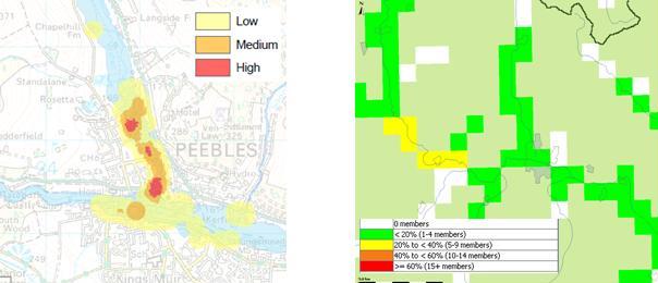
Example of a G2G gridded hydrological forecast (right) and the hazard impact mapping based on categories such as human health, the economy and transport which SEPA are currently developing (left). The project will develop a prototype to merge these capabilities which will ultimately support the Flood Guidance Statement use of the risk matrix based on likelihood and impact.

Pingback: International Conference on Flood Resilience and an award for the SFFS | Scottish Flood Forecasting Service
Pingback: Extreme(?) rainfall in the West Highlands – a flood forecasting challenge | Scottish Flood Forecasting Service