

Synoptic situation at 0000 on 26/10/2014
Over the past few days the forecasting service has faced an interesting challenge. Large amounts of rain were forecast to fall in north west Scotland, caused by warm moist air being driven by gale force winds over the high ground of the west Highlands. Accumulations of the order of 200 mm in two days were expected.
We saw it coming several days before, as the deterministic and probabilistic forecasts were in full agreement that these high totals would appear.

Met Office rainfall forecasts available to the forecasters during the days leading up to the event

Flood Guidance Statement extract showing medium (amber) and low (yellow) risk areas
The challenge of risk based flood forecasting in the Highlands is that our understanding of potential impacts is less than for more populated parts of Scotland. In addition to the Grid-to-Grid model we have rainfall depth duration guidance figures to help with the initial Flood Guidance Statement risk assessment. A lack of data (both on flood events and on river levels) hampered the original derivation of figures for this area, and on this occasion the forecast totals exceeded the 12 and 24 hour guidance figures considerably. A decision was taken to assign a medium (amber) risk status, indicating likely significant impacts. This also matched with the National Severe Weather Warning status for the area.
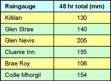
48 hour rainfall totals at some of SEPA’s raingauges in the affected area (NB data not yet validated)
In the event, the rainfall happened as forecast, with over 200 mm being recorded over 48 hours in some areas. There was significant transport disruption, with a number of major routes being blocked by landslides. Apart from flooding of agricultural land and some roads, there was very little in the way of property flooding. The major rivers did not reach extreme levels, partly due to extra storage being available in the lochs and reservoirs following a relatively dry spell. The level of disruption specifically caused by flooding fitted our defined minor (rather than significant) impact definitions. The rainfall was of comparable magnitude to that occuring during the ex-hurricane Bertha event during August; the difference being that the August event affected the east flowing rivers that drain into heavily populated areas, and involved very intense rainfall over relatively short periods, whereas this latest event mostly (but not entirely) affected the west facing more sparsely populated catchments, and involved rainfall spread over a prolonged period of two or more days.
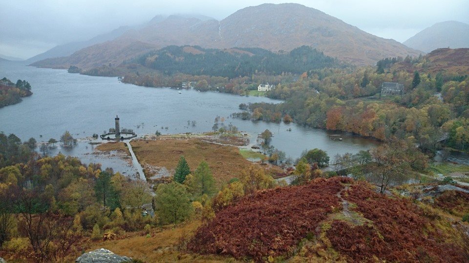
Glenfinnan Monument near Fort William is cut off by flood waters (facebook, unattributed)
The consistent rainfall forecasts meant that we were prepared several days in advance, and the meteorological event didn’t come as a surprise. Following the event we have identified that we need better guidance on impacts from prolonged large total events in this area. This should come from ongoing work in this area, linking river flows to impacts. The role of lochs and reservoirs in influencing river flows in this area also needs to be better quantified.
The data gathered this week will help us to judge this for the next time a 100+ mm event comes along in this area. We will also need to carefully consider the conditions (initial states and rainfall depths and durations) that might lead to a future severe flood in the north west of Scotland.

Pingback: The Scottish Flood Forecasting Service: 2014 in review | Scottish Flood Forecasting Service
Pingback: Grid-to-Grid performance during a hydrologically significant event in the North West | Scottish Flood Forecasting Service