
The decorations are up and the Christmas presents are wrapped but before we leave the SFFS in the hands of our dedicated meteorologists and duty flood forecasting hydrologists over the festive period, there’s just time to review what has been a busy and successful year for Scotland and the forecasting service.
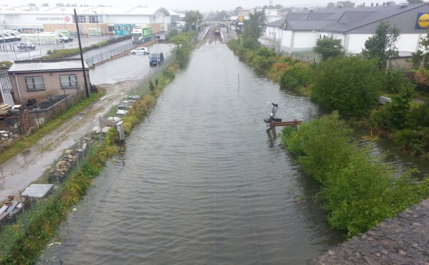
Train services between Inverness and Aberdeen were disrupted in August given flooding to the track through various stretches in Moray (source: Moray Radio online).
A year ago today we were in the middle of the third wet December in a row with 2013 closing with flooding in Nithdale and Dumfries. Although England and Wales suffered a very wet start to the year, Scotland avoided the worst of the rainfall until the summer. The new Moray flood alleviation scheme (still being constructed in some areas) was tested in August when the tail end of tropical storm Bertha hit the north east of Scotland causing widespread flooding. In October the north west of Scotland saw over 200mm of rainfall in 48 hours illustrating just how much water can be stored in the lochs and reservoirs in the region compared to other areas before property flooding occurs.

The island of Stenness in Shetland faced the brunt of the significant Atlantic waves in the December storm (source: Express.co.uk)
Coastal flooding has been a key focus this year. The 18.6 year tidal cycle peaks in 2014-2015 as the orbits of the sun and moon align. This means we are currently experiencing higher than normal astronomic tide levels which could increase coastal flood risk if combined with weather generated tidal surge and wave conditions. Therefore 2014 was a timely year in which to launch our new Moray Firth forecasting system with a sophisticated coupled modelling approach for offshore to nearshore waves and wave overtopping. We have certainly seen some high seas in 2014 with the December ‘#weatherbomb’ storm equalling the highest ever recorded offshore wave height of 16.4m off the Western Isles.
2014 has also seen major improvements in our surface water capabilities. We launched our first bespoke surface water alerting service for the Commonwealth Games in Glasgow and have learnt some important lessons about what type of information is useful to responders and how to best communicate that information, which we will use to inform the development of our surface water services in the future.

Our new FEWS Glasgow forecasts for afternoon of Sunday 3rd August 2014. Photographs show the conditions at the Games at this time. The risk level had been increased as we got closer to the event as the likelihood increased. (photo credit: http://www.eveningtimes.co.uk, http://www.sportsjournalists.co.uk)
There has been a notable rise in the use of social media in flood forecasting this year. SEPA’s own media team (@ScottishEPA) have been doing a great job of tweeting our flood forecasts and warnings for Scotland and making sure that people know where to find up to date information on flood risk.

Members of the SFFS in The Street at Met Office Exeter during a knowledge/science exchange visit in November 2014
As well as developing our own capabilities, the SFFS has been involved in a wide variety of scientific and engagement activities this year ranging from conferences such as the BHS 2014 in Birmingham, technical meetings including the Delft-FEWS user days and EFAS annual workshop, knowledge exchange visits to other forecasting centres at home and abroad and contributed to major research projects including the NERC Flooding from Intense Rainfall project (FRANC & SINATRA).
Thank you for reading this blog over the year. We hope the 5500+ views have given you a useful insight into the varied operational and development work of the SFFS.
From everyone in the Flood Forecasting Service we wish you all a peaceful Christmas and a flood free New Year.

