
As previously reported Storm Desmond caused severe flooding over the weekend of the 5th and 6th December in parts of the country including the Teviot Valley. The River Teviot in Hawick recorded its second highest river flow on record and close to the peak levels recorded in the damaging 2005 flood. However, levels at Ormiston Mill 20km downstream recorded their highest on a record which dates back to 1960. In this article we take a look at what has changed in our capabilities in flood forecasting in the intervening ten years between these two events.

The River Teviot in Crailing in Roxburghshire recording its highest river level on a record spanning 55 years. Copyright Ali Graham Photography.
How do the flood predictions compare?
Meteorological forecasts supporting flooding operations ahead of the 2005 flood did provide early indications with national severe weather warnings activated several days in advance. However for hydrologists what has changed is the access to more detailed spatial and temporal meteorological forecasting tools to help in the decision making process, such as the use of probabilistic rainfall forecasts based on depth and duration. What this supports is the provision of guidance in terms of what is likely, but also what could be expected as a worst case scenario.
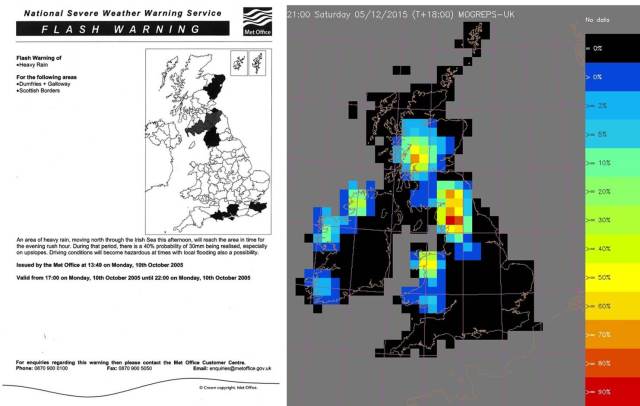
An example of one of the 2005 severe weather warnings for the Scottish Borders, at this time the service was based on fixed rainfall triggers (left). By comparison tools such as MOGREPS-UK that are used now provide guidance on predicted likelihood of a range of rainfall depth-duration, in this case 40mm in 6 hours, with 70% likelihood across the Southern Borders for Storm Desmond (right). Copyright Met Office.
In hydrological terms, a review following the 2005 event noted that warning lead times for this flood on the Teviot were at or around 3 hours and it recommended the development of rainfall-runoff forecasting to increase future lead times. Since then systems have been developed on a catchment scale (PDM) and national scale (Grid-to-Grid) for coupling meteorological and hydrological forecasts and as reported previously this led to flood guidance being provided several days in advance of the recent event. More crucially in the 2015 flood these predictions supported community warnings being issued some 24-hours in advance of the main flooding impacts being witnessed.
Were we more prepared for the 2015 flood?
The 2007 Scottish Government study into the flooding in Hawick, Elgin, Glasgow and other communities looked at societal impacts of these events and specifically one aspect for us how communities respond to flood warnings. At the time the study found that only 33% of those that had previously been flooded used Floodline; only 39.7% moved a car on receipt of warning; and crucially the study found that the effectiveness of a warning largely depends on the time it provides to take appropriate action. The study also noted that although local automatic voice messaging systems were in place (through Scottish Borders Council), there were issues around take up, warning messaging being reliant on two systems and speed and efficiency of warning messaging.
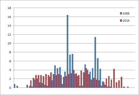
Hourly rainfall recorded across the Southern Uplands. 48 hour accumulation for the 2005 flood (111mm) and the 2015 flood (96mm). Data courtesy of SEPA.
Since 2005, SEPA has introduced a direct warning service of which over 300 individuals are now registered in Hawick, helped with the awareness of the flood risk and active community engagement through initiatives such as the Hawick Flood Group. Although the full extent of the flood is still to be assessed the response to the recent flood from Emergency Planners was that ‘we were much better prepared’ which aided the proactive evacuation of 600 people from the community. Notably whilst reports of the 2005 flood mention cars being washed away, amongst the 100 properties affected initial reports are that not one car was flooded in the 2015 event as a result of the precautionary actions.
What lessons can we take away from the 2015 floods?
Whilst the key points from the 2015 Teviot flood might be that forecasts were reasonably accurate, warnings were timely and the response was proportionate to the scale of the flood, the same might not be true about the neighbouring community of Newcastleton which was equally devastated in 2005 yet escaped major flooding this time.
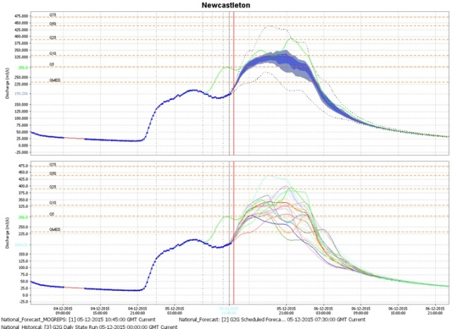
The Grid-to-Grid flow predictions for the Liddel at Newcastleton with a observed peak being recorded at 254 cumecs being closest to the minimum flow ensemble member in these forecasts.
Short range flood predictions for the Liddel Water (see figure) were similar to that of Hawick in that some levels were predicted to be close to those of 2005. However, spatial variation in the predicted and observed rainfall meant that Newcastleton narrowly missed the more severe rainfall accumulation observed across other parts of the southern uplands. This case highlights that flood forecasting continues to be challenging, however the changes over the past decade has enabled us to be more prepared for future flooding.
