
The flood forecasting service has been using Met Office ‘BestData’ rainfall forecasts in its hydrological forecasts since summer 2013. For deterministic forecasts this is a fairly straightforward amalgamation of gridded 1.5km UKV to 36 hours, and 4km Euro4 data out to 120 hours. Only minor configuration changes were required to the Flood Early Warning System (FEWS) Scotland platform on which forecasts are viewed.
The situation with rainfall ensemble data has been more complex. Formerly we received the MOGREPS-R data feed as an 18km and 24 member ensemble. The ensemble members then fed into a suite of Grid-to-Grid (G2G) runs. Following the switch off of MOGREPS-R in summer 2013, and before the full commissioning of the new Met Office Blended Ensemble in 2014, we have adopted an intermediate solution to the problem of an easily configurable appropriate ensemble.
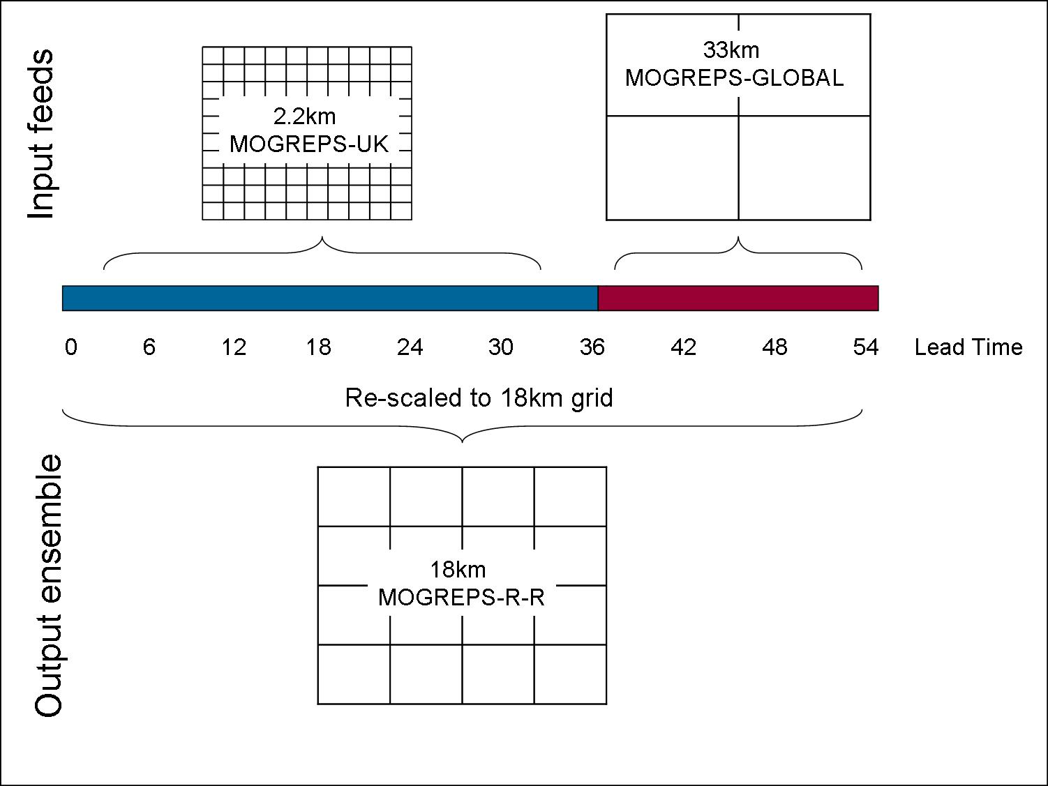
Figure 1 – composition of MOGREPS-R-R feed
This is called the MOGREPS-R Replacement data feed. It presents the same resolution to G2G as the previous feed, however the data for the first 36 hours are constructed from upscaled 2.2km MOGREPS-UK data, and the next 18 hours from interpolated 33km MOGREPS-Global. The forecasting service in Scotland are now the first customers outside the Met Office to be using MOGREPS-UK data in this applied way for operational forecasting. Figure 1 shows the make up of MOGREPS-R-R.
During the summer convective events the new ensemble product appeared more responsive than before, which is to be expected from a product derived from a high resolution forecast. However, for a hydrological model like G2G it is in the field of frontal events giving widespread rainfall that data of this type should show its value. Rainfall events providing river response in recent weeks provided the first opportunity to assess the performance of the new data feeds.

Figure 2 – Ensemble flow forecast from G2G for a typical gauged location. Solid blue is gauged flow, red is deterministic forecast, shaded is ensemble envelope
The signs are very encouraging. On well calibrated locations the deterministic data appear to be providing more or less the correct flow response and most importantly, the new ensemble is providing a better match to the deterministic data than the old MOGREPS-R data used to. As the ensemble has been derived from higher resolution series we had hoped for this and it is therefore good to see it in action.
This should greatly assist with the forecasting decision making process during the early stages of potential flood over the coming months.

Pingback: Hydrometeorological forecasting and ex-tropical storm Bertha | Scottish Flood Forecasting Service