Conference Season

Image

At the Scottish Flood Forecasting Service we are continually developing our tools and knowledge as we strive to be at the forefront of flood forecasting science. You can hear more about our development work at a number of conferences and events this autumn:

  • International Conference on Flood Resilience in Exeter. Come and see our poster on “The use of radar, nowcast and numerical weather prediction in rainfall runoff modelling in Scotland” and speak to us about how being forewarned is forearmed and helps improve flood resilience in Scotland.
  • European Meteorology Society Annual Conference on Applications of Meteorology  in Reading which this year is focussing on High Impact Weather. We will be presenting in the “From NWP and Nowcasts to Forecasts and Warning” session on how we can make the best use of the increasing amounts of deterministic and probabilistic data available to get from a meteorological forecast to the Flood Guidance Statement and flood warnings for Scotland. A lot to cover in 15 minutes!
  • ICE Coasts, Marine Structures and Breakwaters conference in Edinburgh where you can hear about our two new coastal flood warning schemes; the Firth of Forth and Tay model including an early test of the scheme in the December 2012 storm, and an innovative low cost approach to coastal flood forecasting in Loch Linnhe.
Posted in Conference, Flood, Forecasting, Research | Tagged , , , | Leave a comment

Quick as a ‘flash’ (Part 2)

Following the earlier article on the challenges of surface water alerting, Peter Buchanan discusses emerging science developments being used by the flood forecasting service in Scotland.

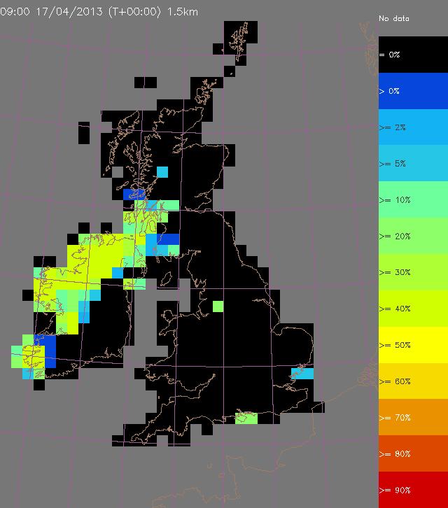
“How does the Heavy Rainfall Alert tool work? In essence, it searches for instances of heavy rain in these weather forecasts up to 36 hours and identifies possible events stratified by threshold and warning area. The HRA tool will also provide a start time, average and maximum rain accumulations associated with the event, and a probability of occurrence. How does it do this? On the assumption that no one forecast of a given heavy rain shower can be taken literally, the HRA tool uses a number of alternative, forecast scenarios to account for the range of possible outcomes.

Where does the HRA tool get its data from? For the time being, it uses the output from a configuration of the Met Office’s numerical weather prediction, designed to make predictions over the UK.  This model has the capability to represent individual large showers and thunderstorms. Predictions out to 36 hours ahead are made every 3 hours. Over lapping portions of successive, 3 hourly predictions are used to produce the range of forecast scenarios mentioned above. Making the assumption that older forecasts will tend to be inferior to more recent forecasts, the HRA tool estimates the likelihood of exceeding a given heavy rain threshold.

HRA output

Example Heavy Rainfall Alert output. (c) Met Office, 2013

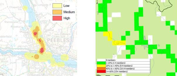
In conclusion, the HRA tool is not a panacea for the forecasting of surface water flooding but it will help alert us to possible impacts in specific areas and provide guidance on the associated likelihood of occurrence.

SEPA, the Met Office and the flood forecasting service in Scotland are committed to a steady improvement in the surface water flood forecasting capability and the HRA tool is a significant step on that road.

So where do we go from here? By 2014, the HRA tool will obtain its rainfall forecasts from a state-of-the-art configuration of the Met Office’s numerical weather prediction model known as MOGREPS-UK (Met Office, Global and Regional Ensemble Prediction System). The main benefits of this model will come from an increase in the number of alternative forecast scenarios (12) it produces. This should enable the uncertainties associated with forecast heavy rain to be better quantified.

The longer term prospects for better prediction of surface water flooding events remain good, with various research projects (meteorological and hydrological) in the pipeline together with further developments in the associated science, technology, observing systems and computational power.

One final thought: if we are to truly get to grips with surface flooding we are likely to need much better weather prediction models and many more alternative forecast scenarios to properly quantify the uncertainties. This will require substantially more super-computing capacity in the years ahead.”

Reference

Roberts, N. M. & Lean, H. W. (2008). Scale-selective verification of rainfall accumulations from high-resolution forecasts of convective events, Monthly Weather Review, Vol. 136, pp. 78-97

Posted in Forecasting, Probabilistic, Weather prediction | 7 Comments

Identifying Flood Hazards in Real Time

SFFS currently have the capability to forecast flows “everywhere” in Scotland, at a 1km grid scale up to five days ahead, using the Grid to Grid model. This includes calculation of snow fall and melt, and the production of probabilistic forecasts. Whilst it is possible to compare forecasts with theoretical indicators of high flows (such as predetermined return periods) and known flood warning thresholds at particular locations, there is currently no simple direct way to determine the actual flooding impact implied by a forecast flow at a point.

Over the past two years SEPA have been publishing outputs from the National Flood Risk Assessment study, including maps of flood risk and potential vulnerable areas. In 2013 we are publishing more detailed pluvial and fluvial maps of flood risk, showing the vulnerability of various receptors, such as human health, the economy and transport.

We now plan to take advantage of these developments and develop dynamic flood impact and hazard assessments, allowing key land areas that are vulnerable and imminently at risk to be readily identified. We will be linking rainfall forecasts and G2G model forecasts with flood impact datasets. The aim is to use the spatial data generated in G2G to facilitate dynamic mapping of a range of flood hazards. We have engaged the Centre of Ecology and Hydrology to carry out this work, which is complimentary to their input to the Hazard Impacts Model being delivered through the Natural Hazards Partnership, of which SEPA and the Met Office are members.

Following these investigations the ultimate aim is to develop a live operational system in which forecast flows will be used to flag up hazards in real time, thereby enabling a more accurate and detailed assessment of flood risk.

Example of a G2G gridded hydrological forecast (right) and the hazard impact mapping based on categories such as human health, the economy and transport which SEPA are currently developing (left).  The project will develop a prototype to merge these capabilities which will ultimately support the Flood Guidance Statement use of the risk matrix based on risk and impact.


Example of a G2G gridded hydrological forecast (right) and the hazard impact mapping based on categories such as human health, the economy and transport which SEPA are currently developing (left).  The project will develop a prototype to merge these capabilities which will ultimately support the Flood Guidance Statement use of the risk matrix based on likelihood and impact.

Posted in Flood, Forecasting, G2G, Hydrology, Risk communication | 2 Comments

Quick as a ‘flash’ (Part 1)

Peter Buchanan, the Met Office flood forecasting service coordinator, describes one of the key priority areas for forecasting science development.

“One of the greatest challenges facing the flood forecasting community for the foreseeable future is surface water or pluvial flooding such as the event seen in Edinburgh in 2011.

There have been steady and tangible improvements in the forecasting of broad scale river flooding events to the extent that these, in the main, are increasingly less likely to spring a nasty surprise on us. As well as improving the quality and reliability of fluvial flooding forecasts there have been complementary gains in forecast lead time and importantly the assessment of risk. The net result has been better, more timely advice and decision making for public and responders and by implication improved security and loss mitigation.

Nonetheless, considerable challenges remain in relation to the prediction of surface water flooding. Why is this? Surface water flooding is usually the outcome of high intensity, localised weather phenomena. By its very nature it tends to be less predictable. As such, it pushes our weather science to the limit. Putting this into perspective, the maximum lead time for a reliable forecast of a thunderstorm is three hours. The maximum lead time for a reliable forecast for a broader scale, rain bearing weather front is typically several days with the difference in scale between features being significant.

It is the small scale and relatively chaotic, nature of heavy rain that makes it very difficult to predict accurately. If we are to justify greater precision in our forecasts in terms of timing, location, intensity and duration we will need to demonstrate significant gains in their accuracy. Although important advances in forecast accuracy have and will continue to be made, the provision of reliable deterministic (yes or no) predictions of localised intense rainfall is likely to remain beyond our capabilities for some years to come.

20130704-150838.jpg
Flooding in Edinburgh. Source: BBC, 2011.

Does this mean we should give up for the time being? The answer is no because our weather prediction models are capable of representing intense rainfall (i.e. they can resolve individual thunderstorms), even if their forecast accuracy in terms of location and timing are uncertain. In other words, we can now be quite accurate in our predictions of the occurrence of intense rainfall even though we are uncertain about its precise location and timing. If we take a probabilistic approach to the prediction of such events, then we can still deliver a service which provides useful guidance and, critically, an objectively based risk assessment.

By applying our knowledge of the uncertainties in the timing, location, intensity and duration of heavy downpours, we can develop sophisticated tools to help us quantify the likelihood and impacts of surface water flooding.

To this end, the forecasting service introduced a Heavy Rainfall Alert (HRA) tool in the spring of 2013. Prior to the development of this tool we completed a study to derive a set of relationships between the intensity and duration of heavy rainfall and its associated impacts for a range of warning areas. A set of heavy rainfall thresholds have been incorporated into an automated tool designed to process numerical weather forecasts and provide those involved in operational hydrometeorology with probabilistic forecast guidance for such events”. Part 2 to follow…

Posted in Flood, Probabilistic, Weather prediction | 4 Comments

Uncertainty in flooding predictions – can probabilistic forecasts help?

At a recent hydrology conference we ran an experiment in flood forecasting. The experiment investigated whether probabilistic information improved decision making. Participants were presented with six forecast hydrographs and were asked to decide whether to open the upstream flood gates for floodplain storage for which they had to compensate the farmer £15000, or to accept the risk and do nothing, in which case if the downstream town flooded they were faced with costs of £40000. In the first game the hydrographs included uncertainty bands showing the possible forecast spread. The second game showed the same six scenarios in a different order and without the uncertainty. bands.

Uncertainty in flooding predictions - can probabilistic forecasts help?

From the 80 hydrologists who took part, three key outcomes were identified from this experiment:

  • there is an improvement in ability of participants to correctly take action in response to forecast when probabilistic data is provided;
  • there is a reduction in cost when probabilistic data is provided, particular from compensation for missed events;
  • and there is evidence of a more risk averse approach when only deterministic data is provided.

The experiment was inspired by work at HEPEX and published research findings can be found through Ramos, M. H., S. J. van Andel, and F. Pappenberger. ‘Do Probabilistic Forecasts Lead to Better Decisions?’ Hydrology and Earth System Sciences Discussions 9, no. 12 (10 December 2012): 13569–13607. doi:10.5194/hessd-9-13569-2012.

Posted in Forecasting, Probabilistic, Risk communication | 1 Comment

EGU General Assembly 2013

Hydrologists involved in SFFS have contributed a paper for this years EGU.  A joint paper with CEH Wallingford was accepted for the session on hydrology for decision-making: the value of forecasts, predictions, scenarios, outlooks and foresights.

EGU presentation on the science and policy supporting flash flood forecasting in Scotland.

EGU presentation on the science and policy supporting flash flood forecasting in Scotland.

The session included papers on varying types of predictions e.g. single valued forecasts, probability forecasts, the use of scenarios and outlooks, for different time scales (short-term, medium-term, long-term) and for different spatial scales (from local to regional to global).
Our contribution focused on presenting scientific developments supporting the latest policy and challenges in flash flood forecasting. The abstract and more details on the session can be found on the General Assembly pages.
Posted in Conference, EGU, Flood, Forecasting | Leave a comment