
Jamie Rae, Senior Scientist with the flood forecasting service, explains the work that has been going into enhancing our surface water flood forecasting capabilities:
As we previously reported on here, In 2022, SEPA published its Flood Warning Development Framework for 2022-28, which included a number of commitments in relation to surface water flood forecasting. One of these commitments was to develop an impact-based forecasting tool which also took account of the uncertainty in the location of forecast convective rainfall.
New Forecasting Tool
This tool, known as PREDICTOR (PREDICTing flooding impacts from cOnvective Rainfall), has now been developed in partnership with the UK Centre for Ecology and Hydrology (UKCEH), using the expertise of specialists in flood risk from SEPA, and experts in convective forecasting from the Met Office. PREDICTOR was adopted operationally by the forecasting service in April 2024.
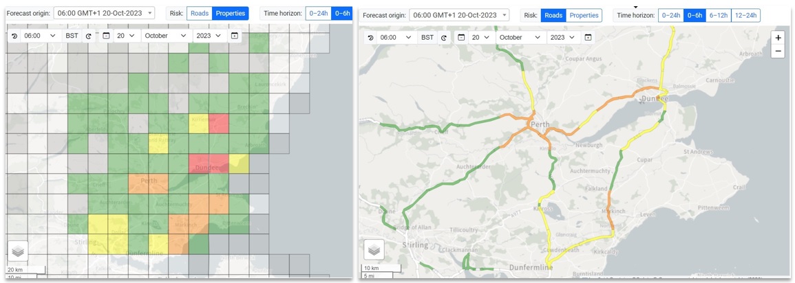
PREDICTOR visualises the surface water flood risk up to 24 hours ahead across Scotland on a grid of 10km x 10km squares. As in the Flood Guidance Statement, the flood risk is assessed via a risk matrix, based on a combination of impact and likelihood (see figure).

Forecasting Impacts
In PREDICTOR, the potential impact of surface water flooding is derived from forecast rainfall exceeding thresholds for minimal, minor, significant and severe impacts. However, whereas standard thresholds were previously used across Scotland (for example, 20 mm in 3 hours equating to minor impacts), the thresholds used in PREDICTOR vary according to location, and are derived from local vulnerabilities to surface water flooding, based on SEPA’s National Flood Risk Assessment 2 (NFRA2) for Scotland.
Likelihood of impacts (i.e. likelihood of rainfall exceeding the impact-based thresholds) is derived from Met Office ensemble rainfall forecasts. Ensemble forecasts involve running the forecast model multiple times, with slightly different starting conditions in each case, to represent the uncertainty in the conditions in the atmosphere, and how this manifests itself as uncertainty in the forecast outcomes. This allows us to forecast the probability, or likelihood, that a specific rainfall threshold will be exceeded in a particular location. In this case, there are 24 ensemble members – that is, the forecast model is run 24 times, with 24 different sets of starting conditions.
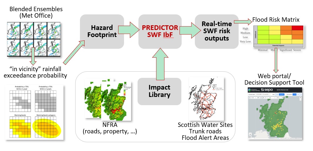
Within PREDICTOR, the outputs from these forecast runs undergo what is known as “neighbourhood processing”, or “in-vicinity processing”, which accounts for the uncertainty in the location of forecast convective precipitation, by assuming that rain that is forecast to fall in a particular location could in reality fall in a nearby location instead.
Going Operational
PREDICTOR was developed in partnership with UKCEH in spring and early summer of 2023, and trialled by SEPA during the remainder of the summer of that year, before being adopted operationally the following April.
Used alongside existing tools, PREDICTOR now gives the flood forecaster a valuable insight into the potential risk of surface water flooding with a lead time of up to 24 hours, and enhances the capabilities of the Scottish Flood Forecasting Service in forecasting surface water flooding, as we work towards implementing the aims outlined in the Flood Warning Development Framework.
